A common mistake contractors make in Cincinnati is assuming that older utility records or as‑built drawings are accurate. Decades of road repairs, private line installations, and shifting fill layers mean that what is on paper rarely matches what lies below the pavement. A GPR (Ground Penetrating Radar) survey provides a non‑invasive way to locate buried pipes, conduits, and rebar before breaking ground. Without this step, crews risk hitting live gas lines or fiber‑optic cables, which can halt a project and trigger costly fines. Pairing GPR with a resistividad eléctrica SEV survey helps differentiate between metallic and non‑metallic targets in complex urban fill.
GPR survey in Cincinnati can detect utilities and voids down to 20 ft, reducing excavation risk in glacial outwash soils.
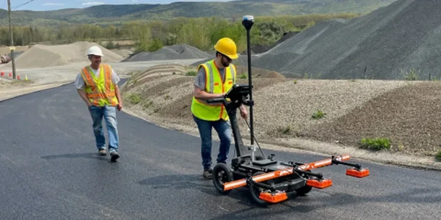
Technical details of the service in Cincinnati
- Site grid setup and calibration to local soil conductivity
- Data collection with 250 MHz to 900 MHz antennas
- Post‑processing using RADAN or similar software
- Color‑coded depth slices and 3D isosurface models
Critical ground factors in Cincinnati
The Ohio River valley contains buried channels filled with sand, gravel, and soft clay that vary dramatically over short distances. In downtown Cincinnati, the water table sits roughly 15–25 ft below grade, but perched water can appear at shallower depths after heavy rain. Without a GPR (Ground Penetrating Radar) survey, a backhoe operator may puncture an unmarked storm drain or encounter a loose fill zone that causes a trench wall to collapse. Even a small void under a sidewalk slab can lead to a trip hazard for pedestrians and liability for the property owner. A GPR survey flags these anomalies before any excavation begins, keeping the work site safe and the schedule on track.
This service complements our laboratory testing work for a complete project analysis.
Our services
We offer three specialized GPR survey services tailored to Cincinnati’s urban and residential projects. Each service is performed with calibrated equipment and follows ASTM guidelines.
Utility Location & Mapping
Scan of paved or unpaved areas to mark metallic and non‑metallic pipes, conduits, and cables. Deliverables include a georeferenced CAD plan with depth annotations.
Concrete Scanning & Rebar Mapping
High‑frequency (1.5–2.6 GHz) GPR survey of slabs, walls, and bridge decks to locate rebar, post‑tension cables, and voids. Results help avoid core‑drilling hazards.
Void & Anomaly Detection
Grid‑based survey of parking lots, sidewalks, or building foundations to identify underground voids, sinkholes, or loose backfill. Data is presented as depth‑slice maps.
Quick answers
How deep can a GPR survey penetrate in Cincinnati soils?
Penetration depth depends on soil conductivity. In the dry sands and gravels of the glacial outwash, we typically reach 15–20 ft with a 250 MHz antenna. Wet clays or silts reduce depth to 5–8 ft. We always perform a test scan on site to confirm usable depth before starting the full grid.
Does GPR work through asphalt or reinforced concrete?
Yes. GPR signals pass through asphalt and concrete with little attenuation. For concrete scanning, we use a 1.5 GHz or higher antenna that can resolve rebar and post‑tension cables up to 18 in deep. The survey is non‑destructive and leaves no marks on the surface.
What is the typical cost of a GPR survey in Cincinnati?
A standard utility‑mapping survey for a residential lot (0.25 acre) ranges from US$9.280 to US$1.100, depending on grid density and site conditions. Larger commercial sites are priced per square foot. Contact us for a site‑specific quote.
Can GPR detect plastic or PVC pipes?
Yes, but the signal contrast is lower than for metal pipes. Plastic pipes are visible as hyperbolic reflections when the surrounding soil is denser or wetter than the pipe material. We adjust the gain and processing filters to maximize detection of non‑metallic targets.
Do you provide a report that can be submitted to the city?
Absolutely. Our final report includes plan‑view utility maps with depth callouts, cross‑section profiles, and a summary of anomalies. All deliverables can be formatted in PDF or georeferenced DXF/DWG for submission with permit applications in Cincinnati.