Cincinnati sits in a region where seismic hazards, though moderate, are far from negligible. The city lies near the edge of the New Madrid Seismic Zone, one of the most active seismic areas in the central United States, and the Wabash Valley Seismic Zone to the west. Historical records show that the 1811-1812 New Madrid earthquakes caused noticeable shaking as far as Cincinnati, and contemporary probabilistic seismic hazard maps indicate a significant chance of damaging ground motions over a 50-year period. This category encompasses the specialized geotechnical and geophysical investigations that assess how earthquake energy propagates through local soils and bedrock, directly influencing structural design, risk mitigation, and public safety.
Understanding seismic hazards in Cincinnati requires a close look at the underlying geology. The city is underlain by Ordovician-age limestones and shales of the Cincinnatian Series, which are typically competent but often mantled by glacial deposits, alluvial terraces, and fill materials. These unconsolidated sediments, particularly in the Ohio River valley and its tributaries, can amplify seismic waves and extend the duration of shaking. A seismic microzonation study becomes essential in such conditions, as it maps variations in ground response across a site or neighborhood, identifying zones where soft soils, buried valleys, or high groundwater may increase liquefaction susceptibility or spectral acceleration values beyond what regional maps suggest.
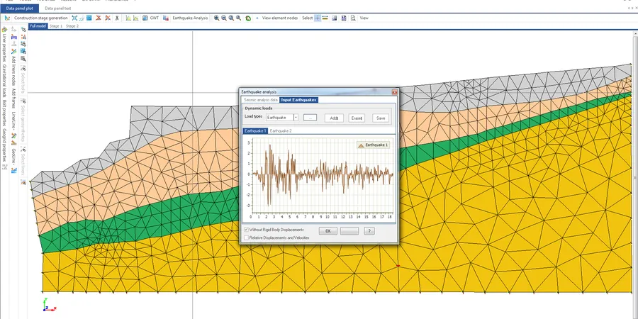
Local compliance is shaped primarily by national standards adopted into the Ohio Building Code. The code references ASCE 7, which requires site-specific seismic hazard analysis for structures assigned to Seismic Design Category D or higher, or where Site Class F soils—such as liquefiable sands or thick soft clays—are present. Additionally, the International Building Code (IBC) mandates site response analysis when simplified classification methods are insufficient. In practice, a site response analysis evaluates how bedrock motions are modified as they travel upward through the soil column, producing design spectra and time histories tailored to the actual stratigraphy rather than generic assumptions. This ensures that critical facilities, from hospitals to emergency response centers, meet performance objectives under the design earthquake.
Projects that routinely require seismic services in Cincinnati span transportation, energy, and commercial development. Major bridge and highway interchanges, particularly those crossing the Ohio River, must account for kinematic soil-structure interaction and potential lateral spreading. High-rise buildings on deep foundations in the downtown basin demand rigorous ground motion characterization, often integrating both seismic microzonation and site response analysis to refine the base shear and drift limits. Even lower-profile structures like schools and water treatment plants, designated as Risk Category III or IV, trigger detailed seismic evaluations per the Ohio Building Code. The growing emphasis on resilience and continuity of operations means that owners and developers are increasingly commissioning these studies early in the design phase to avoid costly retrofits and to satisfy lender requirements for due diligence.
Available services
Common questions
What seismic design standards apply to projects in Cincinnati?
Projects in Cincinnati must comply with the Ohio Building Code, which adopts ASCE 7 for seismic design. This standard requires site-specific seismic hazard analysis for structures in Seismic Design Category D or higher and for sites with Site Class F soils, such as liquefiable sands or thick soft clays, ensuring design spectra reflect actual ground conditions rather than default assumptions.
How does local geology influence seismic hazard in Cincinnati?
Cincinnati's Ordovician limestone and shale bedrock is generally competent, but overlying glacial deposits, alluvial terraces, and fill materials can significantly amplify seismic waves. Deep soil columns in the Ohio River valley may increase shaking duration and intensity, making site-specific studies crucial to capture these effects that regional hazard maps may overlook.
When is a site response analysis required instead of a standard seismic design?
A site response analysis is typically required when simplified code methods are insufficient, such as for structures on Site Class F soils or for tall buildings where soil-structure interaction is critical. It is also mandated for essential facilities like hospitals and emergency centers to ensure performance objectives are met under design-level earthquakes.
What types of projects in Cincinnati benefit most from seismic microzonation?
Large-scale developments, transportation corridors, and utility networks benefit greatly from seismic microzonation. It identifies variations in ground shaking potential, liquefaction susceptibility, and landslide risk across a site, enabling planners to optimize foundation design, land use, and emergency response strategies for spatially distributed infrastructure.