Cincinnati's development along the Ohio River and its historic hillside neighborhoods created a patchwork of cut-and-fill terrains that challenge road construction. The city's glacial till and Kope-Fairview bedrock sequence produce highly variable subgrade conditions within a single block. We combine mechanical stabilization with chemical treatment to address these legacy soils, ensuring the pavement structure performs under heavy truck traffic. Before specifying stabilizer dosage, we always run a clasificación de suelos and Proctor compaction curve to match the binder to the site's plasticity index. This approach has kept roads open on steep slopes like those in Mount Adams and Price Hill where failure would disrupt access for weeks.
On Fairfax Avenue, we reduced subgrade swell from 6.2% to 0.4% using a 4% lime treatment, avoiding a full 300 mm undercut.
Technical details of the service in Cincinnati
Critical ground factors in Cincinnati
The glaciolacustrine clays underlying much of Cincinnati's northern suburbs exhibit plasticity indices above 40, with natural water contents near the liquid limit. When exposed during road cuts, these clays shrink and crack in dry weather, then swell when rewetted, producing differential heave of up to 50 mm across a lane width. If soil stabilization for roads is not designed to handle these volumetric changes, the pavement will show longitudinal cracking within the first two freeze-thaw cycles. We mitigate this by targeting a plasticity index below 15 after treatment and by sealing the stabilized layer with a prime coat within 48 hours to prevent moisture ingress from the frequent spring rains the region receives.
This service complements our laboratory testing work for a complete project analysis.
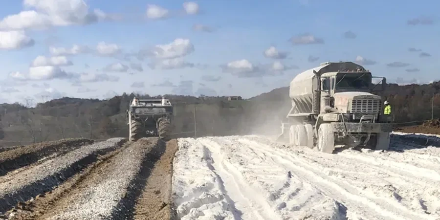
Our services
We offer two complementary approaches for soil stabilization for roads in Cincinnati, selected based on traffic volume and subgrade type.
Cement stabilization for arterial roads
Designed for roads carrying more than 2,000 vehicles per day. We place a 200 mm cement-treated base (CTB) with 5% Type I cement by weight, achieving a 7-day unconfined compressive strength of 1.7 MPa. This method is ideal for widening projects on Reading Road or Montgomery Road where existing pavement is being overlaid.
Lime stabilization for heavy clay subgrades
Applied when the subgrade has a plasticity index above 30, common in the Clifton and Hyde Park areas. Hydrated lime at 4% dosage reduces the PI to below 15, cuts swell potential by over 80%, and creates a working platform strong enough to support dump trucks within 24 hours. We follow with a 150 mm granular capping layer.
Quick answers
What is the typical cost range for soil stabilization for roads in Cincinnati?
For a standard two-lane road section (7.3 m width, 200 mm depth), costs range between US$830 and US$3.300 per 30-meter station, depending on binder type and haul distance. This includes mixing, compaction, and quality control testing. Sites with high PI clays or thick organic layers may fall at the higher end.
How long does the stabilization process take before the road can be paved?
Cement-treated bases can be paved after 7 days of moist curing — usually we pour the asphalt within 10 days. Lime-treated subgrades need a longer mellowing period of 2 to 6 days before final compaction, and we recommend a 14-day cure before placing the base course. Cincinnati's warm summers shorten these windows; cold-weather work below 40°F requires accelerators.
Does Ohio DOT (ODOT) accept soil stabilization for state routes?
Yes, ODOT Supplement 1055 specifies both cement and lime stabilization for subgrade and base layers. We follow Item 304 (Cement Treated Base) and Item 305 (Lime Treated Subgrade) from the ODOT Construction and Material Specifications. Projects on US-42 and I-71 have used these methods with ODOT approval.
What happens if the subgrade has buried utilities or old foundations?
We run a GPR survey prior to stabilization to locate obstructions. If debris is encountered, we excavate to 600 mm, replace with granular fill, and re-stabilize the zone. On the Wasson Way Trail project, we mapped 12 buried utility crossings before mixing and adjusted the stabilizer depth locally to avoid damaging them.