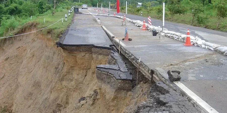
Cincinnati sits on the Ohio River at an elevation of 482 feet, with a subsurface dominated by glacial till over Ordovician shale and limestone. That till varies from stiff clay to loose sand lenses within a single street block. When we design a road embankment here, we first evaluate the existing soil profile through test pits and borings. The goal is a stable, long-term fill that won't settle unevenly or fail during heavy rain. We use the local geology to our advantage, selecting borrow soils that match the site's natural compaction characteristics. Every embankment we design starts with a site-specific investigation, not a generic template. For deeper fills above 15 feet, we often run a georradar GPR survey to map buried utilities or old stream channels before placing any material.
A road embankment in Cincinnati's glacial till demands site-specific compaction curves and drainage control to avoid differential settlement after construction.
Technical details of the service in Cincinnati
Procedure video
Critical ground factors in Cincinnati
ASCE 7-16 requires that embankments in Cincinnati's Seismic Design Category B still consider liquefaction potential in loose saturated fills. The Ohio River valley has pockets of loose sand that can compact differentially during a seismic event. We evaluate the factor of safety against deep-seated failure using Bishop's simplified method, targeting a minimum FS of 1.5 for static conditions and 1.1 for seismic. For fills near the Mill Creek or Little Miami River floodplains, we also check for seepage-induced piping. A poorly designed embankment here can lead to road closures that cost the city millions in repairs, so we take the stability analysis seriously.
This service complements our laboratory testing work for a complete project analysis.
Our services
We offer three core services tailored to road embankment design in Cincinnati:
Geotechnical Investigation & Soil Characterization
We drill borings to 30-40 ft depth, classify soils per ASTM D2487, and run index tests (Atterberg limits, natural moisture, grain size). For every embankment site, we also perform Standard Proctor compaction tests to establish the compaction curve.
Stability Analysis & Embankment Design
We model the fill slope using limit equilibrium software (Slide, SLOPE/W) and check static and pseudo-static stability. For fills over soft ground, we design staged construction with settlement monitoring.
Compaction Control & Quality Assurance
During construction, we provide on-site density testing using nuclear gauge and sand cone, plus moisture control. We issue daily reports and adjust the compaction specification if the borrow soil changes.
Quick answers
How much does a road embankment design study cost in Cincinnati?
For a typical roadway fill of 2,000 to 10,000 cubic yards, the geotechnical investigation and design package ranges between US$1,180 and US$4,430. The final cost depends on the number of borings, lab tests, and the complexity of the slope stability analysis.
What soil conditions in Cincinnati affect embankment design the most?
The main challenge is the variable glacial till. You can have stiff clay in one borehole and loose sand with gravel 50 feet away. We also watch for old stream channels filled with soft alluvium. Each requires different compaction effort and drainage design.
Do I need a seismic analysis for a road embankment in Cincinnati?
Yes, if the fill exceeds 20 feet in height or is located within 500 feet of a known fault line. ASCE 7-16 requires a pseudo-static analysis for Seismic Design Category B. We also check liquefaction potential in saturated loose sands near the Ohio River.