ASTM D2487 and AASHTO M 145 define the standard methods for soil classification in Cincinnati, where the Ohio River valley deposits and glacial till create a complex subsurface profile. We apply the Unified Soil Classification System (USCS) to group soils by grain size and plasticity, then cross-reference with AASHTO for pavement subgrade evaluation. This dual approach is critical for projects along the Mill Creek Valley or on the till plain east of downtown. Before classifying, we typically run a georradar-gpr survey to map subsurface anomalies, and then combine visual-manual procedures per ASTM D2488 with laboratory sieve and Atterberg limits. The classification directly informs bearing capacity estimates and compaction specifications.
A single Cincinnati site can shift from lean clay CL to poorly graded sand SP within 15 feet — classification must be continuous, not spot-checked.
Technical details of the service in Cincinnati
Critical ground factors in Cincinnati
The risk of misclassification in Cincinnati is real. Glacial till behaves like a well-graded material in grain size but can act like a cohesive soil under load. If you classify it solely by the AASHTO rating as A-1-b, you might underestimate its plasticity and later deal with pavement heave. Our team uses a four-person split-spoon crew with a safety-trained driller and a dedicated logger. We run the classification in parallel — USCS for foundation design and AASHTO for pavement layers — and flag any borderline groups before the report goes out. The laboratory at our facility holds ISO 17025 accreditation, so every sieve and Atterberg result is traceable.
This service complements our laboratory testing work for a complete project analysis.
Our services
We offer three core soil classification services tailored to Cincinnati projects, from small residential lots to large highway corridors.
USCS Classification (ASTM D2487)
Full USCS classification including visual-manual logging per ASTM D2488, sieve analysis, and Atterberg limits. We assign group symbol (e.g., CL, SM, GW) and group name for foundation design.
AASHTO Soil Classification (M 145)
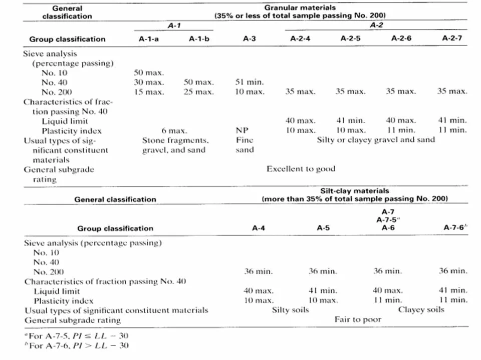
Subgrade rating for pavement design per ODOT and AASHTO standards. We calculate group index (GI) and classify soil as A-1 through A-7, with specific subgroup (e.g., A-6, A-7-5).
Combined USCS + AASHTO Report
Dual classification report that cross-references USCS and AASHTO results. Includes grain-size curves, plasticity chart, and compaction recommendations. Ideal for sites with mixed glacial till and alluvium.
Quick answers
What is the difference between USCS and AASHTO classification?
USCS (ASTM D2487) groups soils by grain size and plasticity for general geotechnical design, while AASHTO (M 145) rates subgrade quality for pavement layers — group index (GI) predicts performance under traffic. Both are required on ODOT projects.
How much does soil classification cost in Cincinnati?
A typical USCS plus AASHTO classification runs between US$60 and US$110 per sample, depending on the number of sieve fractions needed and whether Atterberg limits are included. Volume pricing is available for multi-borehole projects.
What soil types dominate Cincinnati?
Glacial till (CL, SM, GW-GC) covers most of the till plain east of the Mill Creek Valley, with alluvial silts and sands along the Ohio River. Shale bedrock appears at depths of 30 to 80 feet depending on the neighborhood.
Do you accept soil samples sent from the field?
Yes. We accept disturbed bag samples and undisturbed tube samples. The lab requires a minimum of 2 kg for sieve analysis and a representative portion for Atterberg limits. We log them under your project number and return results within 5 business days.