Many of the road failures we investigate in Cincinnati trace back to one root cause: uncontrolled subsurface water migrating through the glacial till and interbedded shales that underlie the metro area. When storm events saturate the lean clay (CL) and silty sand (SM) layers typical of Hamilton County, pore pressures spike and effective stress drops, triggering both pavement heave and shallow planar slides. Our team applies site-specific geotechnical road drainage solutions — intercepting seepage before it reaches the subgrade through trench drains, blanket drains, and prefabricated vertical wicks. Before designing the drainage layout we always run a infiltration test to quantify the soil's saturated hydraulic conductivity, which around Cincinnati can vary from 10⁻⁵ cm/s in the compacted fill to 10⁻³ cm/s in the weathered Upper Ordovician bedrock.
In Cincinnati's shale-and-till soils, intercepting perched water before it reaches the pavement subgrade reduces heave risk by an order of magnitude.
Technical details of the service in Cincinnati
Procedure video
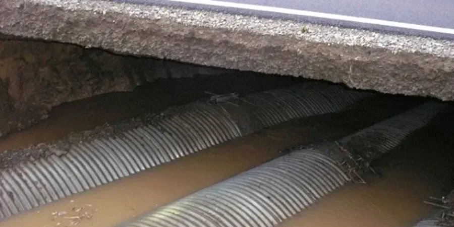
Critical ground factors in Cincinnati
The glacial till in Cincinnati contains discontinuous silt lenses that act as capillary barriers, trapping water within the active zone. When a road cut exposes these lenses, seepage emerges at the face and rapidly erodes the shoulder, leading to tension cracks that propagate into the pavement. In our experience, ignoring lateral drainage in residential street widening projects near Mount Adams or Price Hill causes recurrent slope failures within two to three wet seasons. We have documented cases where perched water only 1.2 m below the surface reduced the factor of safety from 1.5 to 0.95, turning a stable fill into a progressive slide. A properly designed geotechnical road drainage system intercepts that water before it mobilizes the soil mass.
This service complements our laboratory testing work for a complete project analysis.
Our services
We provide the following specialized services for geotechnical road drainage in Cincinnati, each calibrated to local soil and hydrologic conditions.
Subsurface Drainage System Design
Full engineering design of trench drains, blanket drains, and horizontal drains for road cuts and fills. Includes hydraulic capacity analysis, geotextile selection per AASHTO M288, and outlet protection design.
Pavement Subgrade Drainage Evaluation
Field permeability testing, groundwater monitoring well installation, and long-term pore pressure monitoring to assess the need for edge drains or daylighting layers beneath flexible and rigid pavements.
Slope Stabilization Drainage
Integration of drainage with slope reinforcement: installation of prefabricated vertical drains, horizontal wick drains, and stone columns to dissipate excess pore pressure and increase shear strength in fill slopes.
Quick answers
What are the most common geotechnical road drainage issues in Cincinnati?
The primary issue is perched water trapped above the low-permeability glacial till and weathered shale. This causes pavement heave during freeze-thaw cycles and shallow slope failures along road cuts. We also see clogged edge drains due to fine silt migration from the Kope Formation soils.
What is the typical cost range for a geotechnical road drainage study in Cincinnati?
For a standard road segment (2-4 lane miles) including field testing, hydraulic analysis, and design recommendations, the cost ranges from US$790 to US$2,390. Larger projects with multiple drain types and slope stability checks fall at the upper end. The final quote depends on site access and the number of borings required.
Which ASTM standards apply to drainage geotextiles in Ohio road projects?
AASHTO M288-21 is the primary specification for geotextile selection, with ASTM D4751 for apparent opening size and ASTM D4491 for permittivity. For drainage aggregate, we follow AASHTO M43 and ASTM D448. All testing is performed under ASTM D1586 for soil classification and ASTM D2434 for permeability.
How does Cincinnati's frost depth affect road drainage design?
The design frost depth in Hamilton County is 0.9 to 1.2 m per IBC 2018. Drainage outlets must be placed below this depth to prevent ice blockage. We also recommend a capillary break layer of clean, open-graded aggregate beneath the pavement to stop frost heave from drawing moisture upward into the subgrade.