A common mistake we see among contractors in Cincinnati is assuming that a uniform soil profile exists across a hillside lot. The region's glacial till and interbedded clay layers change dramatically within a few feet, especially on the steep slopes near the Ohio River. Without a proper slope failure analysis, a cut made for a driveway or building pad can trigger progressive failure during the next heavy rain. We have seen projects where a simple stability analysis of existing slopes could have prevented a costly retaining wall redesign after construction had already started. The lesson is clear: you cannot rely on a single boring log when the geology shifts so quickly.
A single boring log cannot capture the variability of Cincinnati's glacial till and colluvial mantle; we map the whole slope before modeling failure surfaces.
Technical details of the service in Cincinnati
Critical ground factors in Cincinnati
When we set up for a slope failure analysis in Cincinnati, the field team arrives with a portable drill rig, a survey-grade GPS, and piezometers. The rig has to be small enough to maneuver on narrow residential streets in Clifton or Northside, where access is tight and overhead utilities are common. We install at least two piezometers downslope to capture the phreatic surface during a storm event. That data is critical because many failures in this region occur when the clay layer saturates after 48 hours of steady rain. Without real groundwater data, the factor of safety can be overestimated by 30% or more.
This service complements our laboratory testing work for a complete project analysis.
Our services
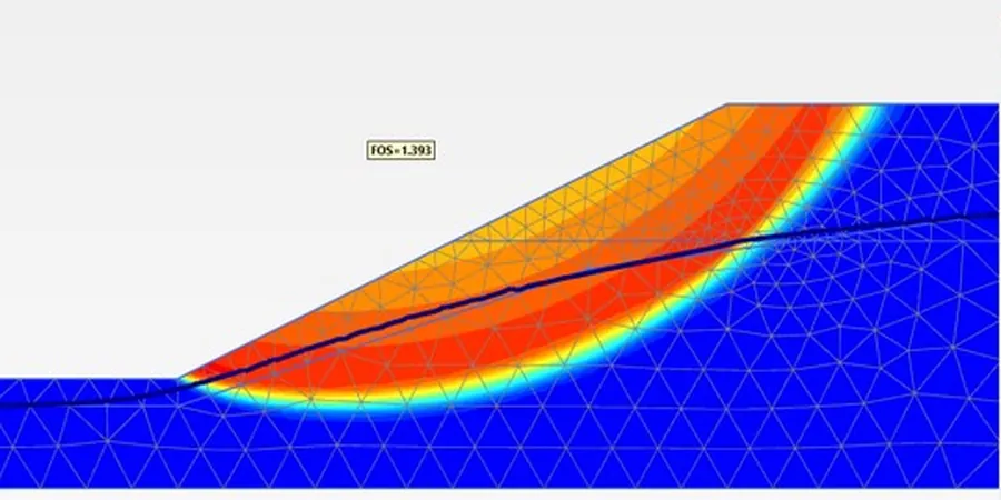
We offer two complementary approaches to slope failure analysis in Cincinnati, depending on the project stage and budget.
Preliminary Slope Screening
A rapid assessment based on existing topographic maps, USDA soil surveys, and a site walkover. We identify potential failure zones, estimate groundwater depth, and provide a preliminary factor of safety using limit equilibrium. Ideal for early due diligence before purchasing a hillside lot.
Detailed Stability Study with Instrumentation
Full analysis including drilled boreholes, undisturbed sampling, laboratory triaxial testing, and slope modeling with Bishop and Spencer methods. We install vibrating-wire piezometers for seasonal monitoring and deliver a report with mitigation recommendations. Used for building permits, retaining wall design, or landslide remediation.
Quick answers
What is the typical cost of a slope failure analysis in Cincinnati?
A detailed study with boreholes, lab testing, and numerical modeling typically ranges between US$820 and US$2,490, depending on the number of exploration points and the complexity of the geology. Preliminary screening costs less but does not replace a full analysis for permit submission.
How deep do you drill for a slope stability investigation?
Boreholes are usually advanced 10 to 20 feet below the proposed cut or fill base, or until competent bedrock is encountered. In areas like Mount Adams where bedrock is shallow, we often core into the rock to confirm the failure surface will not propagate along the soil-rock contact.
Do you include seismic slope stability in the analysis?
Yes. For projects in Cincinnati, we evaluate pseudostatic stability per IBC 2021 using a horizontal seismic coefficient of 0.15g to 0.20g, depending on the site class. We also perform Newmark-style displacement analysis if the static factor of safety is below 1.5 and the slope is critical.
How long does a full slope failure analysis take?
A detailed study with field work, lab testing, and modeling usually takes 3 to 5 weeks. The timeline depends on weather conditions for drilling and the curing time for triaxial tests. We can expedite preliminary screening in 1 to 2 weeks for early decision-making.